
Trace an Enterprise Street Record
Enterprise is an unincorporated Clark County town, so the street-level trail begins with County systems rather than a municipal clerk. Start with the full address you have, including direction and street type when known. The goal is to identify the exact parcel, not to create a list of everyone connected with a road. An owner of record, a recorded party, and an occupant are different descriptions. Keep the source, date, and wording for each one.
The following order turns an address into a careful, reproducible record trail. It also leaves room for a lawful election-status check or a dated historical directory lead without claiming that either source supplies a public street census.
- Enter the address in the Clark County Assessor address form and choose either the current parcel-number record or the present-and-prior-owner option.
- Write down the returned APN, official situs spelling, legal City/Town field, and any subdivision or plat reference.
- Open the APN in Clark County OpenWeb to view parcel context and the linked Assessor, Recorder, Treasurer, and map routes.
- Use the APN, owner name, or instrument number in the Recorder index to follow matching recorded documents backward by date and legal description.
- For a historical address association, use a dated Criss-Cross directory or the authorized individual voter-service or list-request route, subject to its published restrictions.
That sequence is the practical core of by-address research in Enterprise. It separates an address clue from evidence about a parcel, a document, or a historical subscriber.
Enterprise Street Directory Fields
The Clark County Assessor address form is the direct route for an Enterprise street search. Its number box is optional. When a number is supplied, the page says results are within three blocks, so a road-length review may require more than one search. The City/Town control is especially useful because it is a legal-boundary selector, not a postal-city label. Preserve the portal's situs text before normalizing anything for mail.
The assigned Assessor address-form capture shows the field layout used for the search.
View the Clark County Assessor address search before using the captured field order.
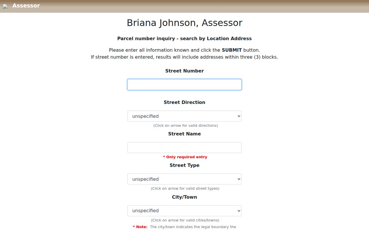
Use the image as a field-order reminder, then confirm the live controls because portal labels can change.
| Field label | Type | Required | Options/format notes |
|---|---|---|---|
| Street Number | numeric text | optional | If supplied, page says results within three blocks |
| Street Direction | dropdown | no | Direction choices were not captured in the research |
| Street Name | text | required for address search | Exact or partial behavior was not captured; preserve official spelling |
| Street Type | dropdown | no | Complete type list was not captured in the research |
| City/Town | dropdown | no | Legal boundary selector; choose Enterprise when known, not Las Vegas merely because of mailing address |
| Phonetic Search | checkbox | no | Assessor page exposes phonetic option |
| Record preference | radio | one choice | Current parcel number record OR present and prior owners |
| Submit/search | button | action | Exact button label may vary by current page |
Try direction and street-type variants when an expected address is missing. A road can cross a ZIP or legal-town line, and an omitted result does not turn the rest of the street into one uniform area.
Enterprise Legal Town Check
Many parcel cards pair a legal City/Unincorporated Town value of Enterprise with a Las Vegas, Nevada mailing line. Neither entry is an error by itself. Enterprise is a Clark County unincorporated town, while Las Vegas is commonly the postal city for the relevant ZIPs. Use the Assessor City/Town field and OpenWeb parcel detail for the legal-location check; use the USPS address result for postal formatting.
The Assessor owner search adds a name route, with a required last name or company and an optional first name. Its current versus present-and-prior setting can uncover a parcel relationship, but it does not establish who occupies the situs address. A mailing address can be an owner's tax-contact location elsewhere.
Open the Assessor owner-search form to compare its current and prior-record controls.
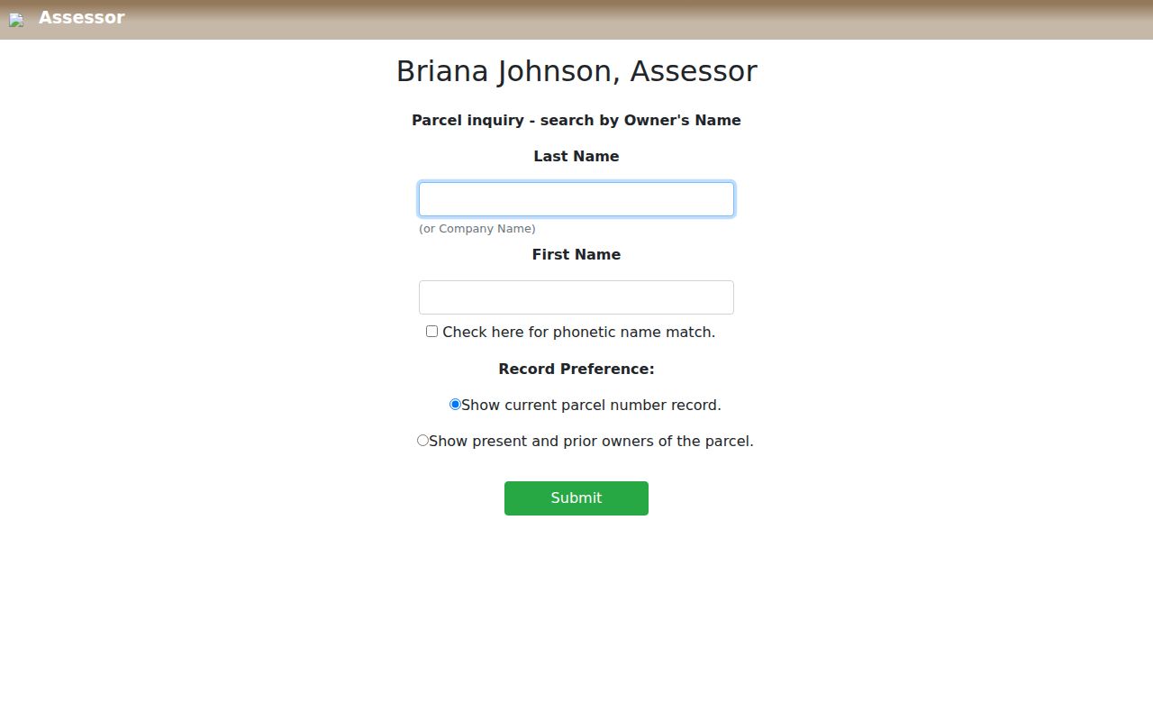
Current and prior choices are useful for parcel history, but their depth varies by parcel and should be recorded as an Assessor result, not an occupancy finding.
Enterprise Streets in OpenWeb
Clark County OpenWeb turns the APN into map context. Its property layer, legal-description layer, zoning, planned-land-use, flood, tax/census, and elected-official layers can help distinguish nearby parcels. Select, multi-select, point, shape, buffer, measure, export, and print tools are available for spatial review. A selected parcel can link onward to Assessor, Treasurer, and Recorder routes.
OpenWeb is a reference viewer with a no-warranty disclaimer. It is not a legal survey, and a map boundary is not proof of title, occupancy, or a personal relationship. For a street segment, record each APN separately instead of copying a visual label for a group of parcels. The linked parcel cards provide the better source for exact situs, legal town, and assessment fields. The County GIS map catalog provides related boundary-map context.
Note: Adjacent parcels can differ in ZIP, tax district, planned land use, and legal town even when their addresses share one street name.
Enterprise Recorder Date Ranges
The Clark County Recorder name index is the next stop after an APN or owner clue. It offers last name, first name or company fields, Starts With, Contains, and Exact match choices, plus book type, date range, document type, and show-names controls. Parcel, instrument, book/page, record-date, total-value, and legal-description modes are also observed. Address searching belongs with the Assessor, not the Recorder.
See the Recorder name-index controls before narrowing a document search.
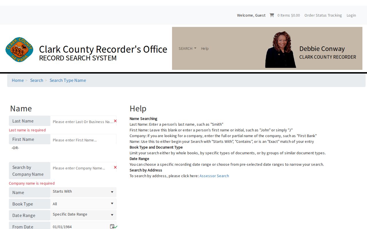
Use an index hit to identify a document and date before requesting a copy. The result is a summary route, not a substitute for reading the recorded material.
The time ranges matter. The Recorder describes microfilm from the County's 1909 beginning through the current year, while the online Official Records index begins in 1988. UCC access begins in 1986 and federal tax liens in 1984. Earlier work moves to Recorder office or branch microfilm research, not a broader web query. The Recorder’s services page distinguishes inspection and copy access, while its statistics page provides the documented coverage context. The office cannot give legal advice or determine parties' rights.
Note: An online index date and a document's recording date are separate facts, so retain both before drawing a parcel-history conclusion.
Define Enterprise Parcel Terms
Street research becomes clearer when the common parcel terms stay distinct. These labels come from the Assessor, OpenWeb, recorded plats, and historical collections, and each has a narrower job than the word “address” suggests.
- Parcel
- A County-assigned land unit identified by an APN. The APN is a research key, not a street number.
- Situs address
- The location address shown for the land. It is different from an owner's mailing or a Recorder party's return address.
- Plat
- A recorded subdivision or parcel map. Plat book/page, lot, block, and legal-description fields help match an instrument to the right land.
- Criss-Cross directory
- A dated reverse directory arranged to find an address or street entry. It can provide a subscriber or household lead for that edition, not a current roster.
For boundary detail, recorded documents and surveys control over an assessment map. For personal identity, a name must be corroborated with source-specific evidence rather than inferred from the parcel label.
Enterprise Address Record Coverage
Clark County keeps address-keyed information in separate systems. The table shows what each Enterprise record set can contribute and where its limits begin. Use the system that matches the question, then retain the access date and record type alongside any notes.
| Record set | Keeper | What it shows | Access |
|---|---|---|---|
| Assessor owner/address/APN | Clark County Assessor | Owner of record, mailing/situs, APN, legal description, lot/plat, tax district, values, construction/sale and structure fields | Public web search; historical-owner option; exact depth varies |
| OpenWeb parcel/GIS | Clark County GIS | Parcel geometry, adjacent parcels, zoning/planned land use, flood, tax/census/elected layers and record links | Public interactive viewer; reference-only/no warranty |
| Recorder index/images | Clark County Recorder | Principal parties, instrument/document, type, recording date/year, book/page; copy/image route | Online index dates differ by record type; older microfilm; copies fee-based |
| Plats/subdivision maps | Recorder/Assessor/GIS | Subdivision, lot/block, plat book/page, legal description, parcel geometry | Assessor/OpenWeb links; Recorder records and map inquiry |
| Tax district/assessment | Assessor/County maps | Tax district and assessed/taxable values | Public map/card; assessment use, not survey/title opinion |
| Building permits/code cases | Responsible Clark County department | Address-keyed work/code record if public | Portal and complete field set not located in official sources; records request fallback |
| Historical reverse directory | Library/UNLV/Nevada State Museum | Dated address-to-subscriber/occupant or household lead | Collection/edition-specific; many in-person or licensed |
| Voter file/reports | Clark County Elections | Registration/status/precinct data subject to NRS 293 | Registered Voter Services and regulated list-data route; no street-wide public lookup captured |
| USPS address | USPS | Mailing ZIP/city normalization | USPS lookup; not legal-town proof |
A Clark County records request can be the fallback when a responsible department holds a public record but no public search interface was located. The central request office is not the custodian for every category, so name the department, record type, date range, and APN or exact address.
Enterprise Criss-Cross Leads
A reverse or Criss-Cross directory is a collection-specific aid for reading an older street. Choose the dated edition first, find the street alphabetically or by address, and record the number, name, subscriber or household notation, edition, and page. The Las Vegas-Clark County Library District genealogy resources, UNLV, museum, and Nevada State Museum holdings have different access rules and years.
Do not assume a modern Enterprise street appears in every historical volume. The research found examples of Las Vegas Criss-Cross editions from 1954 through 1967, territorial directories from 1861 through 1882, and a 1969 UNLV listing, but no guaranteed modern Enterprise run. A missing street can reflect the edition's scope, not an empty place.
A dated directory works best as a historical lead paired with the parcel's construction, subdivision, and recorded-document chronology. For a broader collection search, use the Enterprise city directory resources rather than treating one reverse directory as a complete historical record.
Enterprise Street APN Worksheet
Keep an APN worksheet as each source is checked. This compact record preserves the legal-versus-postal distinction and prevents a mailing address, recorded party address, and situs address from being merged into one label.
| Official street text | Number, direction, name, and type exactly as returned |
|---|---|
| Postal result | USPS-normalized city and ZIP, with the lookup date |
| Legal location | Assessor City/Unincorporated Town value |
| APN | Eleven-digit parcel key and any displayed hyphenation |
| Parcel context | Subdivision, lot/block, plat book/page, tax district, and construction field when present |
| Recorder trail | Instrument/document number, recording date, document type, and matched legal description |
| Historic lead | Directory or newspaper edition, page, date, and the limited association it supports |
| Source control | Portal URL, last-checked date, and a confidence or limitation note |
Note: A complete worksheet makes later corrections possible when a portal refreshes, a mailing line changes, or a street crosses a ZIP boundary.
Enterprise Street Search Limits
Street records do not reveal every person at an address. The Assessor may identify an owner of record and mailing address, while the Recorder may identify principal parties to an instrument. Neither field proves current occupancy. OpenWeb identifies a parcel on a map, not its household. Historical directories may name a subscriber or household lead for one edition, and their terms should remain visible in any notes.
Clark County's live Registered Voter Services flow has protected controls, and its exact public fields were not captured in the research. The Clark County Elections department and its reports offer precinct and district material, walking lists, and regulated data routes, but no public “all voters on this street” result was captured. NRS Chapter 293 includes confidentiality and use limits. DMV address data, utility and delivery customer records, protected voter locations, sealed matters, and confidential-address information are outside this address workflow.
Enterprise Street Growth Dates
Construction and planning dates set a useful boundary for an address search. Clark County identifies Mountain's Edge as an approximately 2,500-acre planned community south of Blue Diamond and west of Rainbow, approved in September 2002; the development agreement was later canceled in January 2022 after later changes. An old regional map or directory can therefore predate a subdivision without disproving a modern parcel record.
Assessor samples cited in the research include construction fields from 2007, 2011, and 2013. Those dates are parcel context, not proof of who lived there. Place a historical directory, map, parcel card, and recorded instrument on separate date lines before linking them. The County's Mountain's Edge history and planning map library supply planning context, not a resident list.